Sunday, July 31, 2011

Fairbanks

Just finishing up our 4 night stay in Fairbanks. Here are a few odds and ends to get the blog up to date:


A couple of souvenirs from Kennecott: On the right is one of the RR spikes that bedevil motorists on the McCarthy Road. You can buy one for $1 at the little museum in McCarthy, but I pried this one out of the road itself.
On the left is a piece of copper ore we found on our hike back to one of the outlying mines.


We stopped off for a couple of nights at Pippin Lake - basically a small community located at the junction of two highways about 5 hours south of Fairbanks. Our little cabin/B&B was really very nice - located right on the lake, and the owners had a variety of watercraft with which to enjoy a day on the water. We tried out the canoe for about 20 minutes, but it was a little too tippy for our comfort level so we switched over to a two person paddleboat in which we circled the lake on a crisp, sunny morning. Made for a very relaxing day.


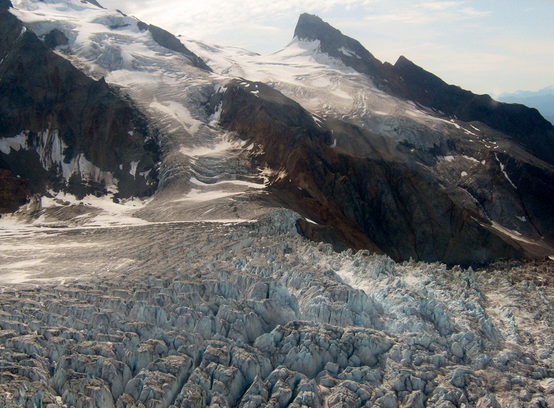
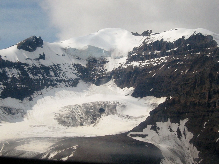
Lots of pretty views of the Wrangell mountains before it clouded up later in the afternoon.


The highway between Valdez and Fairbanks parallels the trans-Alaska pipeline, which starts on the North Slope at Prudhoe Bay and carries the oil down to the port at Valdez. Some of it goes underground, but because of the permafrost much of it has to be above it. It was a frequent companion on our drive north. Apparently, the same atmospheric anomalies that account for the Northern Lights also play havoc with the electronics that power the pumps and heat the pipe all the way south so the whole thing has to be shielded internally.


The highway was in pretty good shape, but parts of it felt as remote as any of the roads we encountered in New Zealand...and with a lot of the same spectacular scenery. Two lanes for the most part, and the speed limit was only 55 until we got within an hour or so of Fairbanks. Traffic very light all the way.

Stopped enroute at Eielson AFB to gas up, grab something to eat, and check out the Exchange & Commissary before checking into our cabin in the small community of North Pole, which is located about 8 miles outside of Fairbanks. As you might imagine, North Pole trades heavily on the Christmas theme...with all of the shops offering Christmas-related merchandise.

Must say that looking at towns and cities on a map of Alaska can be deceiving. I'm used to the symbology of the "lower 48" where if a town is shown as a big red dot it is, in fact, a sizeable place. Not here. For example, we passed thru a place called Copper Center on the drive up. The map symbol for it showed it as a pretty big dot so I assumed there was going to be - you know - an actual town there. Well, Copper Center is basically a Roadhouse with a hotel and cafe, a gas station, and a little museum. That's it. A few homes and very small establishments nearby but that was basically all there was. We actually drove thru and past it, thinking that the "town" had to be just ahead, before we realized that we had just missed it. Have had that happen a lot on this trip. They did have a terrific National Park Visitor Center, however, where we collected a bunch of maps and got some good information on things to see in Denali and on the Kenai peninsula, which are still ahead of us.

Had thought that Fairbanks was a pretty major city too, and by Alaskan standards it is, but the population here is only about 35,000. I keep forgetting that the population of the entire state is only 700,000 people, and that half of those live within the Anchorage metropolitan area. To say the place is rather sparsely populated is an understatement.

This is the land of eternal night (well, almost) in the winter time, and extraordinarily cold temperatures. They actually do get about 3 hours of sunlight per day here in December & January, and they say that it's actually quite pretty. Since the sun barely gets over the horizon it's basically 3 or 4 hours of dusk or dawn - take your pick. The cold is something else, however. Guess the low last winter was -62 in town, and it got down below -70 in the outlying districts. But...it's a dry cold according to the locals. Seems that any humidity in the air just crystallizes in the extreme cold so the air has a fairyland sparkle to it. The snow is so dry that you can't even make a snowball - not enough moisture for it to stick together. Supposed to be like trying to make a snowball out of sawdust.


Rita with the sunflowers outside the Fairbanks Visitor Center.


And under a canopy of Moose and Caribou antlers.


One feature that we both enjoyed was Pioneer Park near the downtown area. Years ago they started saving some of the old cabins that were scheduled to be removed to make way for new development by moving them all here. It's actually very well done (and it's free) and made for a pleasant stroll on a late summer evening. This is looking down the "Gold Rush Town" section.


Most of the cabins are from the 1900-1910 time frame, when Fairbanks was first established as a trading post along the Chena River.They found gold here too, but in this case it was much more difficult to get at since most of it was located at bedrock level...about 100 feet below the surface.

Spent most of one rainy day at the Museum of the North on the campus of the University of Alaska at Fairbanks. Someone had previously recommended it as a great place to see while we were here, and so it was. Lots of artifacts and explanatory material about the various parts of the state, their history of settlement, and how they're doing today. Later, we stopped off at a local multi-plex to watch the last movie in the Harry Potter series.


Rita made a new friend at the museum.


Naturally there was a large display about the various gold strikes in and around this part of central Alaska, and it included this case of ore, dust, flakes, nuggets and finished jewelry. Had several nuggets of pure gold that weighed more than a pound. How much are they worth today at $1400 per ounce?

Drove back to Eielson earlier today to stock up on supplies for our upcoming two week stay in Denali. We're outta here tomorrow for the short 2 hour drive down to the park. Hoping the weather cooperates so we can get in some serious hiking while we're there...and maybe another flight seeing trip around the mountain if the sun will cooperate.

Friday, July 29, 2011

Glacier Flight


OK, here's a trivia question for you: what is the largest National Park in the United States? If you'd asked me that last week I would have said Yellowstone, but actually it's Wrangell-St. Elias NP here in Alaska...the one that McCarthy and Kennecott sit right smack in the middle of. Here are some comparative figures to make the point of just how huge this wilderness area is:

-It's bigger than 6 Yellowstones
-bigger than the entire country of Switzerland (by 25%)...and with higher mountains
-bigger than 9 US States
-9 of the 16 tallest mountains in North American are located within it's boundary

In other words, it's really, really big. So huge in fact that the only way to really appreciate it is from the air, so...when our second day in McCarthy came up sunny and clear we signed up for a 70 minute flight to view as much of the surrounding area as we could squeeze in, which still wasn't even 10% of what's out there. What we did see, however, was incredible. Up to now we had been impressed by seeing glaciers one or two at a time. On this flight we saw hundreds, and each one more beautiful than the last. Saw several that stretched for miles, so far in fact that we couldn't see where they began or ended. There are a couple in the center of the park that are so massive that they can only be viewed in their entirety from space. It's still the Ice Age in Wrangell- St. Elias NP!

I was a Navy pilot for 25 years and saw a lot of beautiful things in the air, but I must confess that this 70 minute flight above Alaska takes the prize for the most spectacular flight I've ever been on. The scenery just kept coming until we were numbed to it.

Anyway, enough of my rambling. Here's a sampling of the photos we took on the flight. As an aside I should mention that usually when we're out and about on one of our excursions we might shoot 10 or 15 photos per day. When we returned from this flight and I downloaded everything onto the computer I realized that we had shot 157...it was that kind of day.


One of several "Ice Falls" formed as the rivers of ice cascade down from the mountain passes.


Those colored striations are gravel deposits that the glacier has collected on its travels as it undermines the softer ground ahead of it. It's all ice, it's just that some of it is topped with gravel.


The glacier blue color of the little ponds formed here and there is absolutely iridescent in the sunlight.


And one short video to top it off.


We left McCarthy on the 26th and spent a couple of nights in a place called Pippin Lake - mainly to break up the drive before we headed up to Fairbanks.

Thursday, July 28, 2011

McCarthy-Kennecott

Our four day excursion into "Outback Alaska" was a real adventure. Did a some hikes, met some locals, took a flightseeing tour of Wrangell-St. Elias National Park and its glaciers, and generally enjoyed just being "off the grid" for 96 hours.


Lots of old abandoned RR trestles along McCarthy Road, like this one about half way in.


The terrors of the drive along the 60 mile McCarthy Road turned out to be greatly overstated. The first 8 miles were pretty rough...lots of washboarding and numerous potholes to be negotiated that slowed our speed to about 15-20 MPH, but after that it was smooth sailing on a well-graded track all the way to the end. The posted speed limit was 35 and I was able to hold that most of the way without squeezing too much juice out of the steering wheel. We had one forced stop for 45 minutes while a State Highways crew inspected a bridge ahead of us, so we got out to stretch out legs. While walking back up the road I came across one of the famous (and dreaded) railroad spikes embedded in the roadbed. Had to pry it up with a makeshift crowbar but I got the little bugger as a souvenir of the trip. The spikes are about 5" long and were once used to hammer the rails in place. After they pulled up the tracks and converted the right-of-way they left the ground littered with the loose spikes which for years were a hazard to tires and oil pans for anyone trying to travel the road...especially after it rained when for some reason the things tended to work their way to the surface. One account I had read in preparation for the trip said that there used to be a 50/50 chance of getting at least one flat tire on any round trip, and there was one tale of some poor guy who motored into McCarthy one afternoon on 4 bare rims, having blown all of his tires plus his spare. Needless to say I was a little concerned going in, but it turned out to be really no big deal. Apparently they ran some super magnet over the road behind a grader a few years ago and managed to clear most of the spikes so it's much safer now.


The end of the road at a pedestrian bridge across the raging waters of the Copper River. Until 1997 the only way to cross was via a hand-pulled basket on a wire that stretched between the two banks.


This the home of Copper River Salmon, a type of Red (Sockeye) that's highly prized. The area was used by Indian tribes for hundreds of years before the Americans showed up around 1900 looking for gold. Didn't find any of that but they did discover the richest lode of copper ore on earth. Apparently, copper ore is worth mining if the concentration exceeds about 5%. The stuff they found here was 70-85%...literally pure copper. The Kennecott Mining Company started building the infrastructure to remove the ore in 1906, and the railway was completed in 1911. Several towns sprang up to support the operations including one around the mill at Kennecott and another about 5 miles down the road in McCarthy. They thrived for years until the copper ran out and operations ceased in 1938. After almost dying both towns have been reborn as remote tourist destinations where you can hike, hunt, fish, walk on the glaciers, white-water raft, and generally try to kill yourself in a variety of creative ways. Kennecott Mines has been taken over by the US Park Service and is now classified as a National Monument. It's essentially a Ghost Town, although efforts are underway to rehab and re-open the old abandoned structures. McCarthy is a real wild west kind of town, with about 50 year-round residents and tons of things to see and do.


This old General Store was once the home (and business) of Kate Kennedy...local madam, bootlegger, and ne'er do well who migrated here from Dawson City and the Klondike gold fields. The local little museum has one room wallpapered with her arrest warrants and notices of violation.


This is the best (actually the only) hotel in the town. Supposed to be pretty nice. We stayed in a very nice cabin on the other side of the river.


And this is pretty much "it" for the rest of the town. Unpaved, pot-holed streets and muddy after a rain, it looked like Dodge City in about the year 1868.


Part of the Kennecott Mine. The little hills just to the left of the structure are actually the Kennicott Glacier, but with gravel on top. When the mine was first built in 1906 the glacier was about 200 ft. higher and blocked the view of the mountains across the valley.


Main Street at Kennecott.


The principal Mill Site tumbling down from the hillside. The process of refining the copper took advantage of gravity to wash, crush, and smelt the ore before it was loaded onto rail cars for the journey to Cordova and, eventually, Tacoma where they were able to extract 98% of the copper from the rock. Was a neat place to wander around for an afternoon.


Just beyond Kennecott there were hiking trails to some of the satellite mines in the area. This one is the Root Glacier track and went about 4 miles back into the bush before terminating at one of the old shafts.


The view from the trail, looking up at the "Bonanza" complex about 4,000 ft. above. They transported the ore from the outlying mines down to Kennecott via a system of aerial tramways. Once mining operations ceased, the company loaded anything of value onto the last train out and left everything else in place.

On our first hike we got about 3 miles into the bush when we met a group of return hikers who said that they had just seen a young Grizzly bear a few hundred yards back up the trail. Having just read about an attack in Yellowstone we turned around and cleared the area...which is what you're supposed to do if you encounter a mother with cubs. Two days later we tried again and this time made it to the end. On the return leg we kept seeing a lot of bear scat full of berries but thought we were home free after we passed into the more frequented pedestrian area near a trail going down to the glacier. No sooner had I safed the Bear Spray and Rita had stowed her bells than we rounded a corner and stumbled upon this Cinnamon Black Bear, sitting in the middle of a berry patch and munching away to his heart's content. Guess he was pretty acclimated to humans because it appeared that we were more surprised than he was, but it did startle us to be that close to a bear all of a sudden. We backed away and I started talking to him in a low voice to see if I could get him to move away so we could pass. He got the idea pretty quickly and lumbered off along the trail, then up into the brush on the hillside above us. Turned out that the first people we had talked to had misidentified him as a Grizzly because of the brown color. Actually it was a Black Bear...but brown in color (it happens), and not nearly as dangerous as a Grizzly. Anyway, it did make for an exciting interlude on the trail.


First time I ever armed my little canister of bear spray. Yes, he really was this close.

During the return drive on the morning of our departure we happened upon this Moose about to enter the lake next to the road, and so slowed down to take a photo and a short video. This really is a unique and special area.


On our second day we sprang for a 70 minute flight to view the vast National Park from the air, but I'll save that experience for the next post. Meanwhile, here's the video of our swimming Moose.


Thursday, July 21, 2011

Valdez

Well, we've had our first big surprise of the trip. I thought Valdez was going to be about as charming as Whittier - it is where the Trans Alaskan pipeline terminates from Prudhoe Bay after all - but it's turned out to be a very pretty little town indeed. Hasn't hurt that the weather has been spectacular for the last couple of days either, starting with our last day in Cordova. The 2+30 ferry ride was gorgeous. Saw a sea otter frolicking in the water next to the ship at the ferry dock while we having breakfast, then saw another 10 or 11 during the 5 mile transit from the bay out into Prince William Sound. Once in open water we saw several pods of Orcas again...what a neat place this is.

We pulled into Valdez around 11 AM and wasted no time taking advantage of the pretty day to explore the town and the surrounding area. Drove over to the fish hatchery on the other side of the bay where the Silver Salmon (Coho) were running up the creek. Must have seen about a million of the not so little guys floundering up the waterway to spawn. Later that afternoon, on our way back from some sightseeing north of town, we returned because one of the Rangers we spoke with said that a young Grizzly was frequently stopping by to feed. Sure enough, no sooner had we pulled in when we heard someone call "bear" and there he was about 100 yards away and working his way towards us as he fished. Will try to remember to post some of Rita's videos of a very fun day at the end of this post. Meanwhile, here are some photos:


Two tourists.


The day was so pretty that we decided to head out to Worthington Glacier State Park about 30 miles north of town. Hiked up to the foot of the glacier you can see behind Rita.


To get to the park we had to traverse Thompson Pass - one of the most jaw-droppingly beautiful drives we've ever encountered. This photo really doesn't do it justice. It was a 360 degree panorama of exactly what you see behind Rita. We just stopped the car, got out at the viewpoint, and gawked at the incredible scene for about 20 minutes.


The juvenile male Grizzly that stopped by at the fish hatchery. Note: this photo was not taken with a zoom lens.


Did a nice hike earlier today near the pass - on the original pack trail from 1899 taken by the gold rush stampeders trying to get to the Klondike via Valdez. Here's a southern view of a northbound Rita on the trail.


The view from the trail.


The trail ended at this viewpoint, where an old bridge had collapsed years before. Made for a great picnic spot for lunch...nobody around for miles.


Same place looking down the valley. Couldn't tear ourselves away from this spot.


Even had ready-made bouquets along the trail.


Trying several short videos. The first is a look at the young grizzly, second is a panoramic view of Thompson Pass, third is a Coho struggling to get past the gate at the fish hatchery (he made it), and finally our sea otter buddy floating by from the ferry.


Heading out tomorrow for McCarthy and the dreaded McCarthy Road ... eater of tires and the cause of many nervous breakdowns.

Monday, July 18, 2011

Cordova


Beautiful downtown Cordova - pride of the Copper River Delta. Population 2240.


This is why we came to Alaska - for scenes like this one. Sheridan Glacier as seen from the Copper River highway. It's like this for 45 miles as the road winds thru the Copper River delta. All of the glaciers are named for Civil War Generals (remember that the US bought Alaska from the Russians in 1867).


Cordova from the harbor. It's very much a fishing town, with the sounds of seagulls and the smells of the ocean permeating everything. You can just see the beginning of the town rising up the hill to the right of the photo. The Good Friday earthquake of 1964 caused the land here to rise 6.5 feet in a matter of a few minutes. This was one of the fishing villages dramatically impacted by the Exxon Valdez oil spill of 1989. Apparently there's still litigation ongoing as a result of the impact it had on the livelihoods of the locals who live on and around Prince William Sound.


One of several Muskrat lodges we saw in the wetlands along the road. Saw several Beaver lodges too.


Childs Glacier at the end of the road.

The Copper River Highway (unpaved) goes for about 45 miles east of Cordova and follows the right of way of the old Copper Valley railroad, built around 1906 to haul copper ore from the rich mines of Kennicott in the interior to the port at Cordova. Both the copper and the railroad are long gone, and the road essentially ends at a local landmark call the Million Dollar Bridge. Child's Glacier is located right across the river from a State campground near the bridge. The face of that wall of ice is about 100 ft. high and it's calving all the time. Saw several fairly large sections collapse into the river just in the time we were there. Once or twice a year a really big section gives way and sends a mini-tsunami up and over the bank on the other side, at which time your only hope is to run like hell for higher ground. It's constantly groaning and cracking too, and there's nothing subtle about it. The glacier is moving about a foot a day I'm told, and it's constantly cracking with the sound of a howitzer being fired at close range. Don't know what it must be like to try to sleep in the campground overnight.


It was a little daunting to sit in this spot having lunch just across from the face, knowing that a couple of times a year the ground I'm standing on is submerged under about 20 ft. of water. One side benefit (assuming you survive the glacial tsunami) is that the wave tosses up scores of sockeye salmon, so you can walk out on the beach and collect a very nice dinner once the water subsides. Unfortunately, the local bears are apparently aware of the mini feast and come out of the forest pretty quickly to take advantage of the free food as well. Just another day in Alaska!


This is the Million Dollar Bridge, originally built to enable the rail connection with Kennicott about 45 miles further up the valley, but now essentially a bridge to nowhere since the road peters out only a mile or two beyond this point. The far span collapsed during the '64 earthquake and was later rebuilt.


Saw lots of berries starting to ripen as we hiked around the area. The place we sat to have lunch was actually in the center of a fairly sizable field of wild strawberries, which will no doubt make it a particularly exciting place to sit in about a month when the bears come down to feast.


On the way back to Cordova we stopped for a short hike thru a meadow of Sitka Spruce, Cottonwoods and Devil's Club. The air was perfectly still and as the cottonwood seeds drifted down thru the trees it lent an otherworldly aura to the whole scene. Was like hiking thru one of the Orc Forests in New Zealand.


Stepping off at the trailhead


A little bush whacking along the way. Saw lots of moose and bear scat but no creatures, probably because Rita was wearing about a dozen bear bells and was making enough noise for an entire circus.
My guess is that she probably scared the scat out of the fleeing varmints with all the racket.


The end point of the hike was this pretty mountain lake at the foot of still another small glacier. Unlike most of the other rivers and streams in the area this lake and the river at its outfall were crystal clear and so aquamarine blue that they almost glowed.


Our botanical education continues...this is Liverleaf Wintergreen. Lots of it in patches along the trail.


They call this plant Wood Sorrel back in Washington State, but here it's called Bunchberry or Dwarf Dogwood. In some places it literally carpets the floor of the forest.


It's a pleasure to just drive around the area. Reminds us of New Zealand in that beautiful vistas seem to open up around every bend in the road.


Have even seen several Ptarmigan with chicks. This Mama bird escorted us along the trail for about 30 yards until we were far away from the fat little babies. In the winter their feathers molt to pure white as camouflage from predators.


Lots and lots of berries in the forest and along the trails. Wanted to stop and collect some of these wild blueberries but the mosquitoes made any stop a life threatening act, so we had to pass them by.

We're here for a couple more days before jumping back aboard the ferry for the short trip to Valdez.