Tuesday, November 23, 2010

Updates

Looks like our short Autumn season has run its course and that we've settled into the long, dark and wet Winter of the Pacific Northwest. The temperature here this morning was a balmy 16 degrees, and that after a light dusting of snow last night. Lots of ice on the local roads so we'll probably be staying mostly inside today. Supposed to be alternately rainy or snowy for the next 10 days although, if the La Nina weather pattern holds true, it will probably be that way until next April.

We are so looking forward to our Christmas trip to Valdosta to see the kids and grand kids next month. Will be nice to get out of here for a few weeks... departing on Dec. 15 and returning on Jan. 10. Have booked a beach house in St. Augustine, FL, for a week after Christmas which should be fun for the whole family, and will be a welcome chance to thaw out and dry out for us.

After that we have a trip planned down to San Miguel de Allende in Central Mexico in Feb. for 6 weeks. Supposed to be a pretty, quiet and SUNNY place. Hope so. This area can really get you down during the winter months.

Vancouver, BC

Realized that I'd never closed out the Canada trip after we returned in September, so here are a few photos from our last stop in Vancouver BC:

We were really looking forward to our stay in the "other" Vancouver. It's often described as one of the prettiest cities in the world, characterized by a sweeping harbor all around, dramatic mountains behind, and numerous parks and green belts within...sort of a mini-Sydney, Australia. Must confess that it's charms were generally lost on us however. Probably didn't help that the weather was rainy and gloomy during our stay, but aside from a few pockets of very nice neighborhoods - most noticeably along the harbor front - the city reminded us of Seattle what with all of the stumble-bums hanging around the downtown area, which gave the whole place a sort of Skid Row ambiance. Really a creepy place once you left the "tourist" areas.

Anyway...not our favorite place in Canada - we much prefer Victoria over on Vancouver Island, which is a short flight or ferry ride across Puget Sound from Vancouver City.

We did have some pleasant outings, however, and here's the evidence:


This is the old Steam Clock in the Gastown area of the city...their "Old Town" district. Located a short stroll from the harbor front - lots of cobblestones, trendy shops and restaurants. Made for a very pleasant day out in the city.


A view of the city skyline from the shoreline promenade in Sydney Park - one of the really pretty city parks that are dotted around the business and residential areas of the city.


Copenhagen has its "Little Mermaid". Vancouver has this "Little Diver" statuette in Sydney Park - one of the stops on a pleasant 6 mile shoreline walk around the peninsula that sticks out into the harbor just opposite the city, and which has some grand views of the town, the harbor, and the strait beyond. Am told that you can often see Orcas and even larger whales passing close to the seawall.

Although Vancouver turned out to be a bit anti-climactic, overall we enjoyed our Canada trip very much. As I've mentioned before the wilderness areas of Alberta and British Columbia rank right up there on our list of the prettiest places we've seen on our travels.

We're already planning a trip for next summer - this time a bit further north into the Yukon and Alaska. Plan is to take the Alaska Marine Highway (ie the ferry) up to Skagway, retrace the route of the Gold Rush Stampeders thru Whitehorse and Dawson City, then meander thru Alaska for about 8 weeks before returning in mid September. Should be quite an adventure. Looking forward to that one, and am greatly enjoying planning it - should keep me busy for the next few months anyway.

Friday, September 24, 2010

More Whistler


Looking down on the town of Whistler from the top of the Gondola. The rock formation to the left of the photo is an Inuit symbol called an Inukshuk, a designation for a landmark or navigational aid. It was also the symbol for the 2010 Olympic Winter Games.

On one of our last days here it came up sunny and clear so we headed up to the top of the mountain on the Whistler Gondola...one of the ski lifts for folks heading into the hills. The ticket actually included a ride on the "Peak 2 Peak" gondola that connects Whistler peak with its sister slopes over on Blackcomb. The Peak 2 Peak apparently has the longest stretch of cable in the world...goes for 2.2 miles from one support tower to the other. In between it's just you, the car, and a string of wire about the thickness of the arresting gear cable on an aircraft carrier - looks pretty unsubstantial when you're suspended about 1500 ft above the valley floor at any rate. Rita is deathly afraid of heights and this trip (a round trip actually) was pretty daunting for her, but she sucked it up, overcame her natural fear, and toughed it out.


Did some easy alpine hikes on the Whistler side before we crossed over to Blackcomb. As you can see, Rita's knees had stopped shaking by the time we broke for lunch at this pretty little pond.


The real fun began on the Peak 2 Peak. That cable goes a looong way over empty air before coming to the support tower on the other side.


Rita gamely trying to keep from peeing her pants during the crossing.


The reward once we crossed over was even prettier alpine scenery on the Blackcomb side. Did one especially dramatic hike that reminded us very much of the alpine valley around Mt. Rainier.


Coming around the bend on the home stretch.


And heading up to our picnic spot at the base of the glacier.


As we came around one corner in the back country I looked down and saw this Black Bear just below us out foraging for berries. There were other hikers in the area, but he seemed pretty unconcerned by the presence of humans...just went about his business getting ready for the long winter sleep ahead.


And a last look at Whistler in the valley below as we re-crossed on the Peak 2 Peak. It really was a terrific day. We walked our legs off on both of the twin peaks, saw some great scenery, recharged with coffee in one of the restaurants at the gondola terminal, and returned to the car late that afternoon comprehensively but happily bushed.

I can see why people like this area so much. Although it caters to a young, active crowd what with all of the skiing, mountain biking, hang gliding, and every other sport known to man, there's plenty to attract anyone who loves the outdoors. Met several young people (well, younger than us anyway) from England & Australia who had come here years ago on holiday from school and just never left. They were working as wait help, tour desk reps, and other visitor-oriented support staff - skiing all winter and biking and hiking all summer in one of the prettiest areas on the planet. Oh to be young again.

Vancouver, BC is next for a few days before we head for home on Sunday. We're actually cutting it short by a couple of days since the weather is supposed to turn sour again.


Whistler

Just completed a most enjoyable week in Whistler - the mountain resort area about an hour and a half north of Vancouver - which was the site of this year's Winter Olympics. We found a nice little 3 bedroom chalet on Alta Lake (about a 15 minute walk from the Village) that made for a terrific base for exploring the area.

The weather hasn't exactly been cooperating lately. When I laid out the trip I was figuring on mild Indian Summer days interspersed with a little rain here and there just to keep everything green. Actually it's been just the reverse and the sunny days have been hard to come by. Still, we've been persevering, donning our waterproof gear and heading out whenever the hard rain lets up enough to do so.

Lots of nice hikes in the area. Similar to Columbia Gorge conditions what with all of the up and downhill tracks. Pretty though, and the rewards after you top out on a long climb are views like those shown below.


A lunch spot at one of the high mountain lakes. This particular one was Garibaldi Lake, like most of the others glacier fed. You can just see the glacier across the lake on the other side.


The sun really did come out occasionally.


On our way up we passed a group of 13-14 year old girls from a private school in Vancouver who were on an outing. They were planning to camp out for 4 nights at the campground at the top of the trail near the lake. Must have been the first wilderness trip for most of them - they had that pained expression that only an afflicted 13 year old girl can muster - but they were hanging in there much to their credit. Must admit that the hike was a relatively challenging one both for the distance and the elevation gained in the climb...especially if you weren't used to it, so their general lack of enthusiasm was to be understood. It started raining as we descended and stayed wet for the next day or so, so their excursion must have been pretty cold and miserable for most of them - just the sort of thing that would create memories they would carry with them for the rest of their lives.

One day we headed north to the little town of Pemberton and stopped off in their Visitor Center to get oriented. Glad we did, as they told us about a place to go just up the road to see the Sockeye salmon run...so that's where we went.


Felt like being in a National Geographic special watching these guys spawning in the river. This is one of the males, who change color on the last leg of their journey from the Pacific. Big too - I thought these were little guys but they looked to weigh about 30 lbs or so.


And one of the females. After laying their eggs (which the males then fertilize) that they both die. We were looking around for bears come to feast on the harvest, but didn't see any.


There was another pretty Provincial Park up the Road that we hiked around to take advantage of the fleeting sunshine. Made for a very enjoyable day.

More of Golden, BC


After re-reading the previous post I realized how much I'd short-changed the area around Golden, which really was one of the prettiest areas we've seen on this trip. Fact is that I'm running out of descriptive superlatives to describe the scenery here that continues to amaze.

Rather than continue to go on about this I'll just present the photos below without too much comment and let you enjoy some of the sights we encountered during our stay in the Columbia River valley of British Columbia.


Looking down on Golden from the Trans-Canada Highway.


The pedestrian footbridge in the town that crosses the Columbia River connecting the two halves of the town.


A pause along one of our hikes.


You need to click on this photo and enlarge it in order to appreciate the color of the water here.


Just another bend along the road on one of our hikes. The pretty vistas go on and on.


From Golden we drove over to Kamloops for a couple of nights. The city is the hub of central BC and a natural stopover between the Rockies and the Pacific Coast. That said, it was a bit of a disappointment after our time in the mountains. Kamloops is situated in the middle of what is essentially desert - pretty arid country all around. Nice to have stopped there but we won't be returning (on purpose anyway) any time soon.

Next up is Whistler.

Thursday, September 23, 2010

Canada Updates

The wireless adapter on my laptop decided to stop working shortly after we left Banff so I haven't been able to update our progress for a while. After many hours of research, diagnostics, system restores and reboots (not to mention invoking all of the swear words I ever learned in the Navy)...and learning WAY more than I ever intended to learn about the software on this computer, I finally managed to get the little SOB working just as we were leaving Whistler.

Here's what we've been up to for the last several weeks:

Calgary

Stayed here for a couple of nights - mainly to break up the trip with a little "city stuff" in between all of the mountain meanderings. We stopped at the Olympic Village from the Winter Games of '88 and then motored in to our B&B in the middle of the city, which we proceeded to explore for the next couple of days. Don't have a whole lot to say about the experience - it's a nice city as cities go I suppose, but two nights was plenty to convince us that we needed to get out of town and back into the wilderness. We don't have too many photos to memorialize the stopover, but we did make an interesting side trip one of the days to Fort Macleod - the original fort in this section of Alberta that was established by the Royal Canadian Mounted Police (Mounties) in 1874 to put an end to a thriving whiskey trade being conducted by American traders with the local Blackfoot Indians. We think of the USA as being a young country but we don't have anything on the Canadians. Some places in Canada (like this one) are barely 125 years old.

The RCMP's were eventually successful and kicked the Americans back across the border. Having earned the trust of the local tribes through their fair dealing on a variety of potentially contentious issues, they brokered a treaty with the tribes of the Blackfoot Confederation in 1877...a treaty that's still in effect and which forms the basis of aboriginal property rights to the present day. Because of all this (and the lack of any major gold discoveries), Canada was able to avoid the destructive wars with the plains Indians that characterized American expansion in the West. The treaty has never been modified (or broken) by either side. An interesting side note is that under its terms each member of the Blackfoot tribe was entitled to an annual payment of $5 from the government, a payment that continues to the present day...and it's still 5 bucks, which doesn't go quite as far today as it probably did in the 1870's.


There's actually a pretty little frontier town at Fort Macleod which built up around this RCMP outpost. It's not a reconstruction - it's the real deal. All of these buildings date from the founding of the post in the 19th century.


After the constraints of the city we were anxious to get to our next stop, which was a self-catering cabin on a horse ranch about an hour south of Calgary.


The Rocky Mountain Foothills

Talk about being in the back of beyond. Our little cabin near the town of Turner Valley couldn't have been further removed from the hustle & bustle of the city. It was located in the foothills of the Rockies (eastern side) at about the 5,000 ft level and about a five minute drive from the entrance to a pretty little Alberta Provincial Park. We arrived just ahead of a drenching rainstorm - in fact we got some hail and sleet at the cabin - and so decided to just stay in for the night and play with the wood stove until it passed, which it did overnight. Next morning was sunny so we headed into the park to explore some of the trails. The first thing we noticed was that the snow level from the previous night's storm was only about 500 ft above us - we basically drove up into it as we ascended the canyon looking for hiking trails. After a couple of false starts due to all of the mud, we found an area along the river that included the waterfall below, which was our picnic spot for lunch. There was a very pretty (dry) trail that paralleled the river going upstream for about a mile and a half - made for a terrific walking day.


The ranch where we stayed is essentially a back-country outfitter for hardy souls wanting to pack it up into the Rockies for a week or so, and they also offered hourly and daily trail rides through the Provincial Park and forest.

Along with all of the horses they had a small herd of buffalo, one of which was standing next to the road as we exited the property one day.


Crowsnest Pass, Alberta

After 4 nights at the ranch we headed south to the small municipality of Crowsnest Pass before turning West again to begin the return leg of the trip. Only stayed here a couple of nights but did stop by the "Head Smashed In Buffalo Jump" historic site along the way down there. In the days before horses (about 5,000 years actually) the plains Indians hunted buffalo on foot. In early Autumn the tribes would converge on a few areas where there were steep cliffs in the foothills of the plains and stampede all or part of a buffalo herd over the edge of it, where other members of the tribe were waiting to butcher the animals quickly, ie before the meat turned bad. This place was named after a young brave who was watching the buffalo tumbling over the cliff one afternoon and got stuck in the middle of the animal avalanche...hence the name. The last time the site was used in this manner was the mid 1850's, after which time all of the hunting was accomplished from horseback. I always associated the plains Indians with horses but they didn't actually get them until the early 1700's - courtesy of some of the early Spanish expeditions into the interior of the continent in the 1600's.


Head Smashed In Buffalo Jump in Southern Alberta


Another side trip was to Waterton National Park, which borders our Glacier National Park across the international border on the Canadian side. You can actually hike or ride from one country to the other (if you have your passport). Really a pretty place and one we had been to a couple of years ago as a day trip from Glacier when it was unfortunately raining. Didn't have any better luck this time - it was cold and showery when we arrived but, having driven this far, we decided to go ahead a drive the two scenic roads that penetrate into the back country. Glad we did. The rain let up a bit as we left Waterton Village and we saw lots of pretty scenery and creatures. Saw a black bear emerge from the forest just ahead of us as we rounded a curve - even "herded" him along for a bit before he tired of the game and bolted into the forest. Also a resident herd of deer which, as you can see from the photo of the yearling buck below, aren't at all skittish around cars or people.


Rita took this just leaning out of the window of the car as we paused alongside.


At the end of the drive was a pretty little lake that had a short 3 mile hiking trail along the right-hand side. The far end of the lake (looking south) is the US. You can actually walk across the border here if you continued beyond the viewpoint.

You can get a good idea of the type of day it was from these two photos. And this was the dry part of the day. Still, the park was beautiful as advertised. Just wouldn't mind seeing it in sunshine at least once before I die.


Golden


After the two nights in Crowsnest Pass we continued West, crossed back into British Columbia, and stopped in the town of Golden - located just west of Lake Louise on the western side of the Rockies. Stayed 4 nights on a Buffalo ranch, in a nice 3 bedroom house they offer as a self-catering place on their property...complete with hot tub! It was another remote site, nestled against another Provincial Park just above us along a logging road. As we got out of the car we heard an elk "bugling" in the forest above us - it was rutting season...felt like we were in the movie Jeremiah Johnson all the time we were there.

As expected there were numerous hiking opportunities in the area. All we had to do was drive 15 minutes up the logging road, which paralleled a mountain river, to find isolated walking tracks. So isolated in fact that we had the bear bells jangling the whole way and had the bear spray at the ready...just in case. No bear encounters but boy what pretty scenery. The photo below was our lunch spot after hoofing it into the bush for an hour or so.


One day we drove about 45 minutes up to Yoho National Park, which is located only about 20 minutes from Lake Louise as you descend west from the Continental Divide. Didn't think it possible but it was actually prettier than Banff or Jasper - and a lot less crowded. More great hikes and views of magnificent waterfalls as you can see.


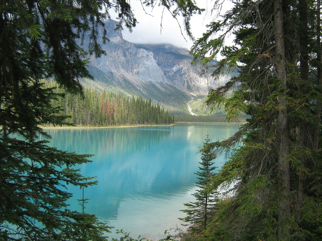
The water in the rivers and lakes up here is all the same aquamarine blue color that we first saw in New Zealand a couple of years ago - and for the same reason. It's ice melt from the glaciers above. Apparently all of the grinding of the ice wears away the underlying rock and creates what they locally call "rock flour" - or silt, basically, but so fine that it really does have the quality of flour. And boy does it get into everything. The car looked like it had just emerged from the Outback after driving the local roads for a couple of days and was extremely difficult to get either off the car or out of all the nooks and crannies in the molding that I never thought dirt could get into.

The silt is so fine that it doesn't merely dissolve in the water as it's carried along - it's actually "suspended" in it, ie it will never just settle out once it hits a still patch of water like a lake. That's why all of the local waters have that "glow in the dark" quality that looks so pretty on a sunny day. Emerald Lake is advertised as the most beautiful of the Rocky Mountain lakes - surpassing even Lake Louise. See for yourself.


The photos above and below are of Emerald Lake in Yoho, one of many drop dead gorgeous places in the National Park


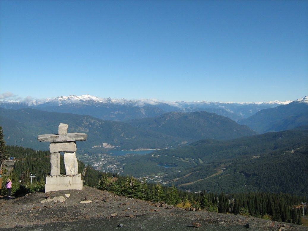
After Golden we continued West towards Kamloops, our stop along the way to Whistler.

Tuesday, August 31, 2010

Banff

Looking down on Banff Township from the hills above.

I think we may have found a place that's as pretty as New Zealand - the place that's always been the benchmark for all of our travels. The area in and around Banff and Jasper, and everything in between, has to rank at or near the top of any listings of the world's most beautiful places. We've enjoyed the week here very much and really hate to have to leave tomorrow to head on down the road to Calgary.

Our hikes here have truly been world class - spiced up with the occasional animal sighting - and the little township of Banff was a delight in itself. Not at all overrun with tourists as we had feared. It was an easy walk into town from our little self-catering cottage in one of the residential areas, and our week long stay permitted us to enjoy the place at our leisure rather than having to run around and squeeze everything in over the course of just a few days. Didn't even have to drive out of town for terrific hikes...just had to walk to the end of a block in virtually any direction and continue on into the hills. Just had to be alert about the bears!


Looking up the street from our cottage.


Pretty scenery everywhere.


Along one of our riverside walks.


A little further up the trail.


The Banff Springs Hotel - the grand old lady of the Bow River Valley. A gorgeous place but bring your wallet.


A moocher on the trail. You're not supposed to feed any of the wildlife but it's hard to resist these guys. We saw one at the Lake Agnes Tea House near Lake Louise the other day that was actually obese from chowing down on all of the tourist handouts. It was quite a sight...a fat chipmunk.

They apparently had a bumper crop of Buffalo Berries this year, which is one of the staples of the diet of both Black Bears and Grizzlies as they fatten up for the long winter ahead. Guess when they're actively gorging themselves they get pretty preoccupied and it's easy to startle them if you come upon them in the forest. Since the berries are abundant along the valley floor, ie along the hiking trails, you really have to be careful (and prepared) as you work your way along. Several popular hiking trails were closed completely due to bear activity, and many others were restricted to groups of 4 or more people - all of whom needed to be equipped with "bear bells" to alert the bears of your approach (and minimize the potential for a surprise encounter), and bear spray as a last safety resort. Nobody gets too excited about any of this - it's just the way it is if you live or travel in the wilderness. Just have to be properly prepared is all.


The Buffalo Berries were ripening all over the valley floor next to the trails.


They're serious about their bear advisories around here. Kept seeing these warning signs about every 1000 yards along the trail. Parks Canada has a terrific website that includes trail conditions and reports of bear activity that they update nearly every day. Several of the trails we wanted to hike were closed due to bear activity, and others had bear advisories (proceed at your own risk) posted.
Noticed that there was even an entire valley near one of our hikes, stretching about 30 miles to the south and covering several hundred square miles, that was closed completely as a reserve for foraging animals. Along with the bears there are also wolves, coyotes, moose and elk in the forests here.


On one of our hikes we took an alternate route back towards our car and came upon this elk cow as we rounded a corner. Didn't seem too skittish even though we were making a lot of racket thanks to our bear bells. As we approached she just melted into the forest. As we passed we peaked through the foliage where she had disappeared and saw a second female along with a huge (I mean really magnificent) stag. Must have been at least a 16 pointer and stood about 6 feet at the shoulder...about 20 feet away from us. Fortunately it wasn't yet rutting season or we might have been at risk of a charge - they're pretty cantankerous when their blood is up - as numbers of tourists in Yellowstone find out every September when the normally docile herd that hangs out in the Mammoth area becomes very aggressive and the males do a lot of damage to passing vehicles (and occasionally their occupants). No problems this day however. Just couldn't get a photo thru the trees.

Leaving tomorrow morning for the short 90 minute drive out of the mountains to Calgary, where we'll be for just a couple of days.

Monday, August 30, 2010

Birthday Hike at Lake Louise


The view across Lake Louise from the Chateau.

We celebrated my birthday by driving about an hour north of Banff to Lake Louise - another stunning place in this magnificent area - to spend the day. Rather than driving up the Trans Canada highway with the rest of the tourists we opted to try an alternate route - the Bow River Parkway - which parallels the other road but is a two lane meander thru the forest. Whereas the main highway is usually clogged with bumper to bumper traffic transiting the corridor, with road construction delays added just to increase the fun factor, the Bow River route was almost deserted...had it almost to ourselves anyway, which made for a very pleasant and scenic 45 minute trip. Even saw some critters along the way - two huge Elk stags browsing along the side of the road.

Once at the Lake we walked around the Chateau Lake Louise - the big European style hotel that dominates the small village and which features prominently in all of the tourist brochures of the area. Really was a pretty place. Styled to evoke the image of a Scottish castle. And sitting right at the edge of the lake with views up to the distant glaciers...as you can see from the accompanying photos.


Another look from the grounds of the hotel.


Looking back at the hotel from the Shoreline Walk.

As usual we had our hiking gear and decided to wander up the shoreline trail to Lake Agnes about 1,000 ft. above Lake Louise, where they have a tea house - a very European thing that I've only seen before in Germany or Switzerland. After an hour's slog uphill it was neat to emerge onto another beautiful vista and to be able to sit down and enjoy a hot beverage and a snack. Since the trail we hiked is the only way in or out, supplies have to be brought in every few days by horseback...a mini pack train.


Heading up to Lake Agnes.


Rita at Lake Agnes on a pretty day.


The view from the trail. Makes Lake Louise look like the world's largest lap pool, doesn't it?

After a short rest we opted to continue via a connector trail that eventually brought us to another tea house located further in the back country - in an area called the Plain of the Six Glaciers. Another scenic hike up into a secluded valley. Stopped there for lunch and to rest our weary legs before the trek back down the hill. I was a bit taken aback at the thought of paying $8.00 for a peanut butter & jelly sandwich...until I saw the sandwich. Made with hikers (and calories) in mind, it was made of home made brown bread sliced extra thick and then slathered with the PB and J. God it was good - and probably would have fed a family of four for about 3 days. Wandered around the vicinity for a half hour or so - just marveling at the views of all the glacial peaks around us - and then headed home just as the "afternoon rush" seemed to be arriving. I was frankly surprised at how many people were arriving - it was a good 4 mile hike to get there after all - and at how poorly prepared most seemed to be. Inadequate footwear, no rain gear or warm clothes, etc. It was as if they started out on the shoreline trail in front of the hotel, which is quite easy and totally flat, and then just decided to go for it apparently believing that the rest of the hike was the same grade as the first mile. Anyway, we saw some sorry looking touristas that half looked like they might have to be helicoptered out once they finally arrived at the tea house.


Nearing the end of the trail.


And finally, the view from the end of the valley. There really were 6 glaciers in the little amphitheater around us.

Drove back to Banff along the same parkway that we came up on. Really relaxing, and always with the chance to see wildlife grazing next to the road.

Don't really have anything significant or profound to say about turning 64. The only thing to be said in favor of getting older, once you've reached a certain age, is that it sure beats the alternative.

I'm reminded of a quote attributed to Babe Ruth, who said that he knew it was time to retire from baseball when all of the baselines started to seem as if they were running uphill. I'm starting to know how he felt.

A few more days here in Banff before we head to Calgary.